Home Multi-Country Search About Admin Login
Cenozoic
Cretaceous
Jurassic
Triassic
Permian
Carboniferous
Devonian
Early Paleozoic

Search by
Select Region(s) to search
Hold Ctrl (Windows/Linux) or Command (Mac) to select multiple
Phu Phan Formation
Click to display on map of the Ancient World at:
Phu Phan Fm base reconstruction

Phu Phan Fm


Period: 
Cretaceous

Age Interval: 
Lower Cretaceous (13, 14, 15)


Province: 
Indochina Block: Khorat Plateau, Indochina Block: Loei Fold Belt

Type Locality and Naming

Phu Pha Phung, Phu Phan Range, Kalasin province of Khorat Plateau (La Moreaux and others, 1959; Ward and Bunnag, 1964; Iwai and others, 1968). Parent unit: Khorat Gr.

Synonym: หมวดหินภูพาน

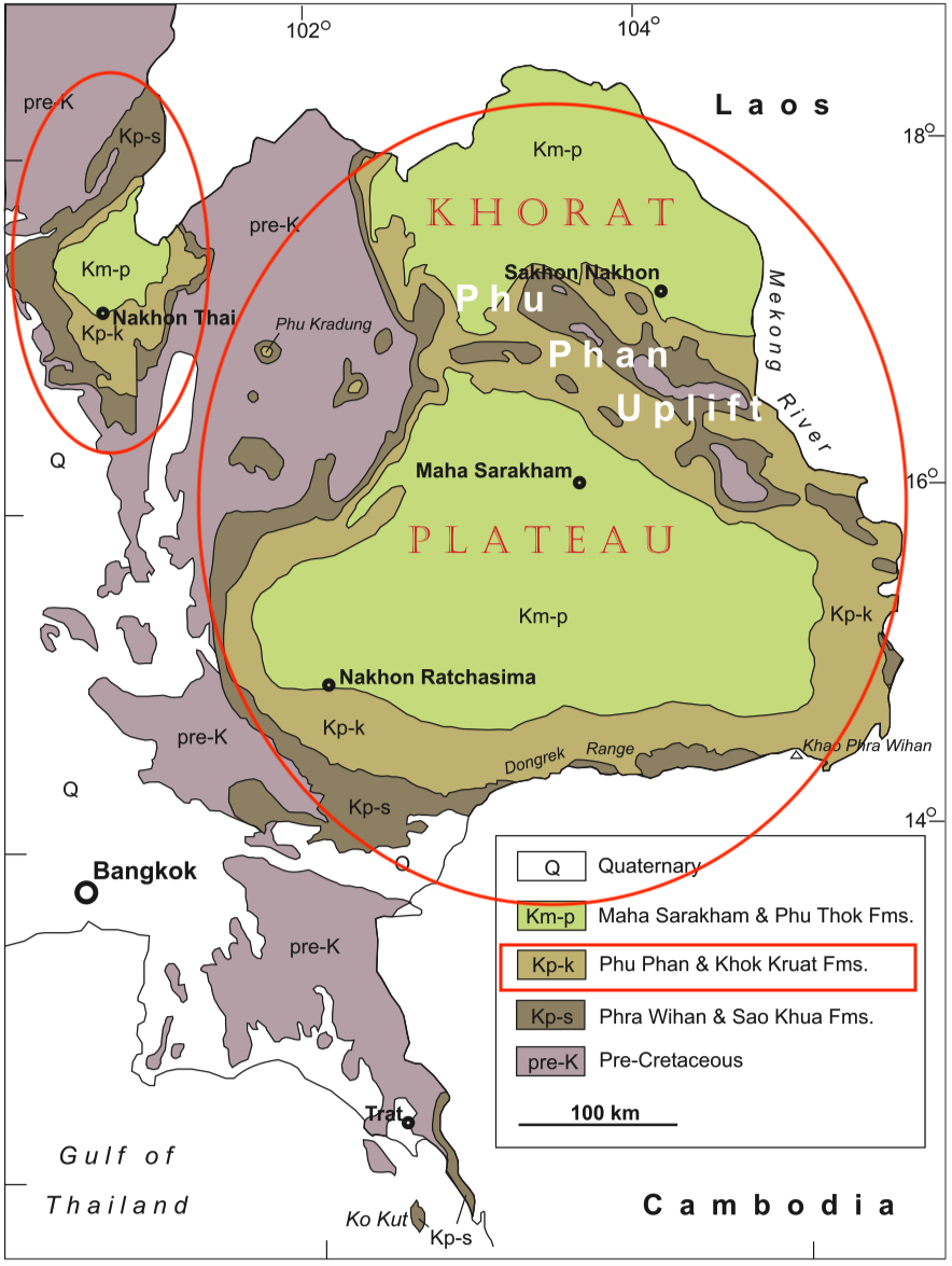
[Figure: NE and SE Thailand, showing distribution of Cretaceous outcrops. (Meesook, 2011. Page 170). At least some of the Pre-Cretaceous sedimentary rocks on the map may be Jurassic and the position of the Jurassic-Cretaceous boundary is discussed in Meesook (2011).]


Lithology and Thickness

The rocks generally consist of greyish-white medium- to coarse-grained cross-bedded sandstones and thin lenses of grey siltstone and mudstone with subordinate conglomerate. In the northern and central parts of the Phu Phan Range, the formation overlies the reddish-brown claystones of the Sao Khua Formation with a distinctively sharp but conformable contact.

Sandstone conglomerates are locally exposed, particularly at the Kaeng Kabao Rapids along the Mae Khong River banks, Mukdahan Province, and at Pha Nam Thip in Roi-et Province.

The Phu Phan Fm sandstone in the south-eastern part of the Khorat Plateau is slightly coarser than elsewhere in Northeast Thailand and is well exposed along the Mae Khong River banks in the vicinity of Pha Taem National Park in Khong Chiam District, Ubon Ratchathani Province (Meesook, 2011).

Thickness: 183 m

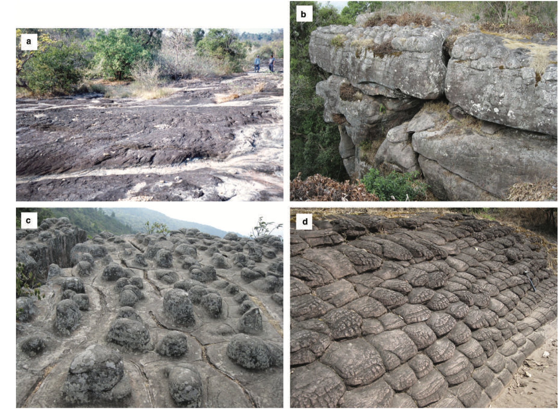
[Figure: Phu Phan Formation in Northeast Thailand. (a) Large-scale, planar, cross-bedding in conglomeratic sandstones in Mukdahan Province (photograph courtesy of T. Wongprayoon); (b) thick-bedded sandstone at Phu Hin Rong Kla in Phitsanulok Province; (c) weathered surface of horizontal bedded sandstones at Phu Hin Rong Kla in Nakhon Thai District, Phitsanulok Province; and (d) unusual weathered surface resembling tortoise shells in subhorizontal cross-bedded sandstone at Phu Hin Rong Kla in Nakhon Thai District, Phitsanulok Province (Meesook, 2011).]


Lithology Pattern: 
Coarse-grained sandstone


Relationships and Distribution

Lower contact

Sao Khua Fm (conformable)

Upper contact

Khok Kruat Fm (conformable)

Regional extent

The Phu Phan Formation is well exposed along the Mae Khong River banks and in most parts of the Phu Phan Range where it forms cuestas which delineate the outer rims of the range of the Khorat Plateau (Meesook, 2011).


GeoJSON

{"type":"Feature","geometry":{"type":"Polygon","coordinates":[[[100.86,17.97],[100.84,17.82],[100.73,17.64],[100.5,17.26],[100.28,16.84],[100.18,16.41],[100.28,15.88],[100.48,15.55],[100.45,15.3],[100.53,14.96],[100.66,14.73],[100.91,14.5],[101.11,14.45],[101.51,14.44],[102.13,14.69],[102.42,14.84],[102.67,14.92],[102.84,14.96],[103.08,14.98],[103.24,15.04],[103.43,15.12],[103.51,15.18],[103.65,15.34],[103.72,15.57],[103.73,16.03],[103.66,16.46],[103.45,16.87],[103.16,17.27],[102.66,17.53],[102.29,17.74],[101.89,17.99],[101.7,17.96],[101.63,17.81],[101.48,17.81],[101.34,17.66],[101.16,17.49],[100.98,17.53],[100.93,17.66],[100.99,17.81],[101.1,17.99],[100.86,17.97]]]}}

Fossils

From the Sao Khua Formation up into the Phu Phan Formation, fossils again decrease in diversity as was observed from the Phu Kradung to the Phra Wihan Formations. Only dinosaur footprints are observed in sandstone beds at Phu Luang, in the Phu Luang Wildlife Sanctuary near Loei (Buffetaut et al. 1985a, b). Some palynomorphs from the Phu Phan Formation are also recorded, for example, Cyathidites minor and indeterminate bisaccate pollen (Racey et al. 1994, 1996; Racey & Goodall 2009), on the basis of which the formation’s age is thought to be in the range Berriasian to Aptian.


Age 

Lower Cretaceous; Lower Cretaceous (? Barremian-Aptian) by Racey and others (1994). Spans only early-Aptian following Booth, J. & Sattayarak N., 2011, Chapter 9 Subsurface Carboniferous-Cretaceous geology of NE Thailand.

Age Span: 

    Beginning stage: 
Aptian

    Fraction up in beginning stage: 
0

    Beginning date (Ma): 
126.30

    Ending stage: 
Aptian

    Fraction up in the ending stage: 
0.3

    Ending date (Ma):  
122.35

Depositional setting

The depositional environment is interpreted to have been predominantly braided, high-energy, low-sinuosity rivers with subordinate floodplains in a warm, humid paleoclimate (Meesook, 2011).


Depositional pattern:  


Additional Information


Compiler:  
Wen Du - modified from- Meesook A., 2011. Chapter 8 Cretaceous in Ridd, M.F., Barber, A.J., and Grow, M.J., editors, The Geology of Thailand, Geol. Soc. of London.

Booth, J. & Sattayarak N., 2011, Chapter 9 Subsurface Carboniferous-Cretaceous geology of NE Thailand in Ridd, M.F., Barber, A.J., and Grow, M.J., editors, The Geology of Thailand, Geol. Soc. of London; Lexicon of Stratigraphic Names of Thailand of 2013.